Hurricane center tracks 3 Atlantic systems that could develop
Published in News & Features
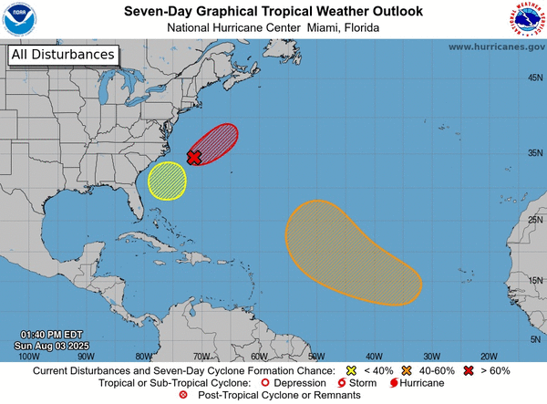
The National Hurricane Center continued Sunday to track three systems in the Atlantic with the potential to form into the season’s next tropical depression or storm.
As of the NHC’s 2 p.m. tropical outlook, it had increased chances for a system off the U.S. East Coast to form while also forecasting a tropical wave to roll off the African continent, where it could find good conditions within a wide swath of potential development as it moves across the Atlantic. The NHC is now also tracking a third system off the southeastern U.S.
The more likely of the two is what is now a nontropical area of low pressure along a frontal boundary about 180 miles off the coast of North Carolina with disorganized showers and thunderstorms.
“While satellite wind data show that the low is now producing gale-force winds, the system remains attached to a frontal boundary,” Forecasters said. “However, environmental conditions are conducive for this system to acquire additional tropical characteristics, and a tropical storm is likely to form by Monday well east of the North Carolina coast.”
The NHC increased chances it could develop to 70% within the next two to seven days. The agency first began tracking it on Sunday afternoon.
If it were to develop into a named storm, it could become Tropical Storm Dexter.
The other system with the NHC’s attention would be a tropical wave expected to move off of the west coast of Africa in the next two days.
“Thereafter, some gradual development of the wave is possible during the middle to latter part of next week while it moves generally west-northwestward across the central tropical Atlantic,” forecasters said.
The NHC gave it a 40% chance to develop in the next seven days.
The third system off the southeastern U.S. has a low chance of development over the next week.
“An area of low pressure could form in a couple of days a few hundred miles southeast of the Carolinas,” Forecasters said. “Some gradual development of this system is possible by midweek as the system drifts to the northwest.”
The NHC gives it a 20% chance to develop within the next seven days.
Before the start of hurricane season, the National Oceanic and Atmospheric Administration had forecast an expected 13 to 19 named storms for the year, of which 6 to 10 would grow into hurricanes. Three to five of those would develop into major hurricanes of Category 3 strength or higher.
So far the season has seen three named systems, all tropical storms, but none since Tropical Storm Chantal fell apart on July 8. The height of hurricane season runs from mid-August into October.
The entire six-month season runs June 1 to Nov. 30.
_____
The National Hurricane Center continued Sunday to track two systems in the Atlantic with the potential to form into the season’s next tropical depression or storm.
As of the NHC’s 8 a.m. tropical outlook, it had increased chances for a system off the U.S. East Coast to form while also forecasting a tropical wave to roll off the African continent, where it could find good conditions within a wide swath of potential development as it moves across the Atlantic.
The more likely of the two is what is now a nontropical area of low pressure along a frontal boundary about 180 miles off the coast of North Carolina with disorganized showers and thunderstorms.
“Environmental conditions are marginally conducive for this system to become a tropical or subtropical depression or storm today or on Monday while it moves east-northeastward at about 10 mph, away from the coast of North Carolina,” forecasters said. “After Monday, environmental conditions become less conducive for development.”
The NHC increased chances it could develop to 50% within the next two to seven days. The agency first began tracking it on Sunday afternoon.
If it were to develop into a named storm, it could become Tropical Storm Dexter.
The other system with the NHC’s attention would be a tropical wave expected to move off of the west coast of Africa in the next two days.
“Thereafter, some gradual development of the wave is possible during the middle to latter part of next week while it moves generally west-northwestward across the central tropical Atlantic,” forecasters said.
The NHC gave it a 30% chance to develop in the next seven days.
Before the start of hurricane season, the National Oceanic and Atmospheric Administration had forecast an expected 13 to 19 named storms for the year, of which 6 to 10 would grow into hurricanes. Three to five of those would develop into major hurricanes of Category 3 strength or higher.
So far the season has seen three named systems, all tropical storms, but none since Tropical Storm Chantal fell apart on July 8. The height of hurricane season runs from mid-August into October.
The entire six-month season runs June 1 to Nov. 30.
_____
©2025 Orlando Sentinel. Visit orlandosentinel.com. Distributed by Tribune Content Agency, LLC. ©2025 Orlando Sentinel. Visit orlandosentinel.com. Distributed by Tribune Content Agency, LLC.


Comments