Hurricane center predicts new Atlantic system could develop
Published in News & Features
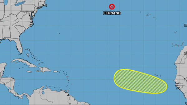
ORLANDO, Fla. — The National Hurricane Center on Thursday began to forecast a system could form in the Atlantic that could develop into the season’s next tropical depression or storm.
As of the NHC’s 8 a.m. tropical outlook, the agency said a tropical wave would emerge off the west coast of Africa on Sunday.
“Thereafter, environmental conditions could support some slow development of this system while it moves westward to west-northwestward at 15 to 20 mph, moving across the eastern and central tropical Atlantic next week,” forecasters said.
The NHC gave it a 20% chance to develop in the next seven days.
If it develops it would be the seventh tropical cyclone of the season and could become Tropical Storm Gabrielle.
The sixth, Tropical Storm Fernand, became post-tropical early Thursday located 635 miles east-southeast of Cape Race, Newfoundland moving east-northeast at 23 mph with maximum sustained winds of 45 mph.
Only one of the six named storms has reached hurricane status. What had been Hurricane Erin, which grew to Category 5 major hurricane status with 160 mph winds, ended up not making landfall, but did prompt warnings in the Caribbean and U.S. Atlantic coast earlier this month.
The National Oceanic and Atmospheric Administration in early August updated its season forecast to call for 13-18 named storms this year, of which five to nine would grow into hurricanes. Two to five of those would develop into major hurricanes of Category 3 or higher.
The height of hurricane season runs from mid-August into October while the entire six-month season runs June 1 to Nov. 30.
------------
©2025 Orlando Sentinel. Visit at orlandosentinel.com. Distributed by Tribune Content Agency, LLC.


Comments