Climate change nearly tripled size of Boundary Waters wildfires, study suggests
Published in News & Features
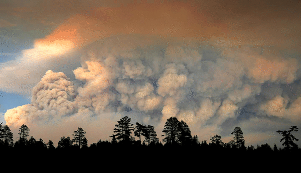
MINNEAPOLIS — Global warming likely intensified the wildfires that raged for months this summer in the Boundary Waters and Canada, according to new research from the University of California, Merced. The intensity, in turn, made the smoke more hazardous to breathe.
The findings shed new light on a devastating summer in Minnesota.
State officials in July shut down the Boundary Waters for the second time in five years after historic wildfires, worsened by drought and a blistering heat wave, scorched an estimated 64,000 acres. The smoke from the fires stretched from the Midwest to New England and triggered air quality index numbers previously unseen in the state.
The study’s authors examined the four days the wildfires burned most intensely, from July 13 to July 16. During that time, the fires scorched nearly three times more land than they would have without the effects of global warming, the study concluded.
Because the fires burned more land, the study added, the smoke released contained especially high levels of fine particulate matter pollution, or PM2.5.
That type of pollution is a byproduct of any fire, including the combustion taking place in a car engine. The particles are so small that when they’re breathed into the lungs, they can pass into the bloodstream, potentially causing cardiovascular and lung diseases or a host of other health conditions.
The U.S. Environmental Protection Agency estimates that exposure to PM2.5 leads to as many as 300,000 premature deaths each year in the United States.
Using similar techniques as the federal government, the California-based researchers concluded that PM2.5 exposure due to the July wildfires would result in nearly 500 more premature deaths in the U.S and Canada than if those fires had burned in a world without human-caused climate change.
“Because there’s more smoke, there’s higher concentrations of PM2.5, and that is absolutely more dangerous,” said Dmitri Kalashnikov, a co-author of the study. “There’s no healthy amount of PM2.5.”
Kalashnikov’s team came to these conclusions through a process called counterfactual modeling, which uses powerful computers to simulate realistic “what if” scenarios that can’t be observed in the real world.
Economists use this kind of modeling to predict possible financial consequences to implementing various policies. Clinicians use it to explore potential treatment outcomes when it’s too risky or unfeasible for a patient to try all options.
Counterfactual modeling has long been at the heart of climate scientists’ work. By simulating an alternate Earth, where humans emitted more or less carbon pollution, resulting in more or less warming, scientists can more accurately ascribe what influence, if any, climate change had on any given weather event.
“We’ve always had extreme weather,” Klashnikov said. “There’s really no way to say whether climate change ever caused any given event.”
But by modeling the same event in an alternate reality, scientists can at least find correlations that suggest climate change did in fact influence the frequency or severity of a hurricane, wildfire or other natural disaster, he added.
“So you can say global warming made this heat wave three degrees hotter than it would have been in a world without human-caused climate change, or climate change increased the odds of this kind of intense heat wave fivefold. It would have been five times less likely in the 19th century,” Kalashnikov said, using a hypothetical example.
Stefan Liess, a researcher in the University of Minnesota’s Department of Soil, Water and Climate, uses this modeling technique to project how Minnesota’s temperatures and precipitation might change under different warming scenarios — say, whether the planet’s average temperature heats by 5 degrees or 8 degrees Fahrenheit above preindustrial levels by the end of the century.
Mapping out those hypothetical scenarios, Liess said, can provide vital information for government officials, city planners or even farmers who want to know what kind of runoff to expect in the future, or which months they should expect the best soil moisture.
Climate models have come a long way since the first one was developed in 1956, Liess said.
“Accuracy increases over time because you have more researchers looking for bugs and errors,” Liess said, noting that the biggest improvements have come from scientists adding new variables to their models, such as how cloud cover influences warming and weather patterns.
Still, even the oldest climate models, which took into account very few variables, predicted modern surface temperatures with surprising accuracy, a 2019 study found. Most of the models closely matched real-world temperature observations once differences in actual greenhouse gas emissions were accounted for, the study concluded.
Both Liess and Kalashnikov said that climate models also have their limitations. They pointed out that models are better at long-term projections and they become less accurate the closer you zoom in.
Right now, Liess said, most climate models that researchers use can only make predictions within an area of about 4,900 square miles, roughly the size of the state of Connecticut. He and other researchers at the university hope to improve the models so that one day they can provide detailed climate projections at the county level.
Kalashnikov said his study has yet to be peer reviewed, but he plans to submit it to journals later this year.
©2026 The Minnesota Star Tribune. Visit at startribune.com. Distributed by Tribune Content Agency, LLC.





Comments